White Planet - Antarctica

The sea ice has melted back along this part of the Antarctic coastline (below)during summer, exposing the rocky beach.
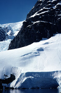
The sea ice has melted back along this part of the Antarctic coastline (below)during summer, exposing the rocky beach.


  |
(left) The author's husband, at "the end of the world", Ushuaia, Argentina. (right) A view of the City of Ushuaia as we leave Ushuaia, aboard our modified Russian ice breaker, traveling east along the Beagle Channel. The snow-capped Andes Mountains can be seen in the background with a distinct line where the snow has melted for the summer. |
| Ushuaia, Argentina, at 54 degrees 46 minutes south latitude, is claimed by the Argentineans as the southernmost city on Earth. This is where the Andes Mountains (that run in a north/south direction along Chile) turn and run east (for just a short distance) at the end of the range. Ushuaia is on the south side of the Andes, is the capitol of the province of Tierra del Fuego in Argentina, and is renowned for its cross-country skiing. It is 150 km from Ushuaia to Cape Horn (the southernmost tip of South America) and 4,000 km to the South Pole. There were only about 7,000 people in Ushuaia in the early 1990s but by the year 2000 there were over 45,000 due to a governmental promotion to revitalize this area (high wages and no taxes). With a new airport and deep water port, Ushuaia has become the major city for Antarctic departures of the large ice breaker vessels that travel to and from Antarctica. |
  |
(left) The Las Eclaires Lighthouse, an unmanned lighthouse, remains as an historical landmark in the Beagle Channel and an aid to navigation. Most large vessels must be escorted through the Beagle Channel by an Argintinean "pilot boat" as they come and go from Ushuaia. (right) Looking east toward the end of the Beagle Channel, the Atlantic Ocean looms ahead and the dreaded rough Drake Passage. |
| The city of Ushuaia looks south, across the Beagle Channel. It was in the mid 1800s that Charles Darwin sailed through here in the now famous vessel, the Beagle (after which this channel is named). Leaving Ushuaia by way of the Beagle Channel the real crossing begins when the vessel enters the Atlantic Ocean, and passes Cape Horn. |
 |
Cape Horn on an unusually calm day (December 28, 2000). We are within two miles of the Cape. |
| Many of the early explorers lost their lives here at Cape Horn as they attempted to get from the Atlantic Ocean to the Pacific Ocean. There are numerous tales of fighting the wild seas at Cape Horn for days, weeks and even months and still being unable to round the Cape. It is an unusual day that one can venture close to the Cape. |
 |
Starting across the Drake Passage. |
| The area between Cape Horn and the Antarctic Peninsula is called The Drake Passage and has some of the roughest ocean waters in the world. The Drake Passage was so rough that the continent of Antarctica was not discovered for a long time because explorers just could not get across it. This passage has an average wind speed of 44 km/hr. and an easterly flow of ocean water (from the West Wind Drift current) that puts 8 times the volume of the Gulf Stream (formerly thought to be the fastest current) through the passage each day. It usually takes 2 full days and nights to get across "The Drake." If the seas are not too high (up to 30 foot swells during the summer) there are seabirds and whales to be sighted. Most passengers must "pay the Drake" during this 48 hours of crossing before they can enjoy the wonders of Antarctica. Occasionally a crossing will not hit any rough seas (only 6-12 foot swells) and the Drake Passage will be called the "Drake Lake." |
 |
The Antarctic Convergence is not very spectacular to look at but the drop in temperature of the ocean water here is a major barrier to life forms that are not adapted to freezing temperatures. |
| Antarctica can be defined in three ways. The first way is the outline of the continental land mass and its permanent ice. The second is to use the Antarctic Circle (at latitude 66.5 degrees south) and consider everything south of that latitude to be Antarctica. The third way is perhaps the best for considering the entire Antarctic as an ecosystem - this is to use the Antarctic Convergence as the defining line. The Antarctic Convergence occurs in the ocean surrounding Antarctica and is where very cold (low salinity) Antarctic water, flowing away from the continent and constantly cooled by the ice on the continent, meets with the southernmost parts of the Pacific, Atlantic, and Indian Oceans. The Antarctic water is denser, because it is so cold, and sinks, creeping north across the ocean bottoms. South of this convergence not only is the ocean water colder but the air is distinctly colder and drier than north of the convergence. Most of the life forms found in Antarctica depend on the ocean within the Antarctic Convergence so using this as a definition for Antarctica encompasses the entire physical area that is important for the complex ecosystem that is found there. The convergence moves north during the Antarctic winter, and south in the Antarctic summer - in response to the freezing and thawing of the sea ice. This Convergence is a biological barrier to organisms both in the ocean and the air because of the big temperature difference. Ice |
|

|

Ice Shelves
|

Ice Shelf, above, a permanent part of Antarctica. The shelves never melt back to the continent and are actually mapped as the edge of the Antarctic Continent. |
| In some areas of Antarctica the glaciers flow along the continent, toward the ocean in such a manner that they spread out and are relatively flat for some distance on the continent. If these glaciers are thick enough, and not subject to a lot of cracking, they may form permanent ice shelves along the edges of the continent. This is common on either side of the Antarctic Peninsula (the Ross Ice Shelf, to the west, and the Ronne Ice Shelf, to the east). The ice shelves may be grounded near the edge of the continent but are usually floating along their outer edge although the ice may be over 800 feet deep at the edge of shelf. The face of most of the permanent ice shelves is around 100 to 200 feet high. It is very difficult to get ashore along these ice shelves (although not impossible) and it may be dangerous if the shelves are cracking. Some of the largest ice shelves are so permanent that their edges actually show up as the edges of the continent (like the Ross and Ronne Ice Shelves) and some have permanent scientific outposts and/or weather stations established on them. When pieces of these ice shelves crack and break away, they may be very large and have a uniquely flat top (thus they are called table bergs). One of the largest such table berg was the size of the state of Delaware (named the B-15 iceberg, it was 185 by 23 miles) and broke away from the Ross Ice Shelf about March of 2000 changing the outline of the Antarctic continent. |
| Tidewater Glaciers |
|

 |
Icicles form along the melting edge of the ice sheet, on the beaches of the Antarctic Peninsula, during the summer months. |
The breaking of the ice shelves, the calving of the tidewater glaciers, and evaporation just about balances the constant movement of the glaciers out from the pole. This results in the amount of ice in Antarctica staying about the same every year (at least during our historical time). |
Icebergs
|


+Hindi+Movie+Mp3+Songs+Free+Download.jpg)